2. Technical Service in the Basins of Tributaries of Po, Emilia Romagna Region 42100, Italy
The Emilia region in the eastern sector of the Po Plain in Northern Italy (Fig. 1) was affected in May 2012 by two earthquakes of Mw 6.1 and Mw 5.9, followed by several aftershocks up to Mw 5.1[1]. The stars showed in Fig. 1(a) indicate the location of the two major epicenters. Schematic regional cross section of the alluvial plain (Fig. 1(b)).
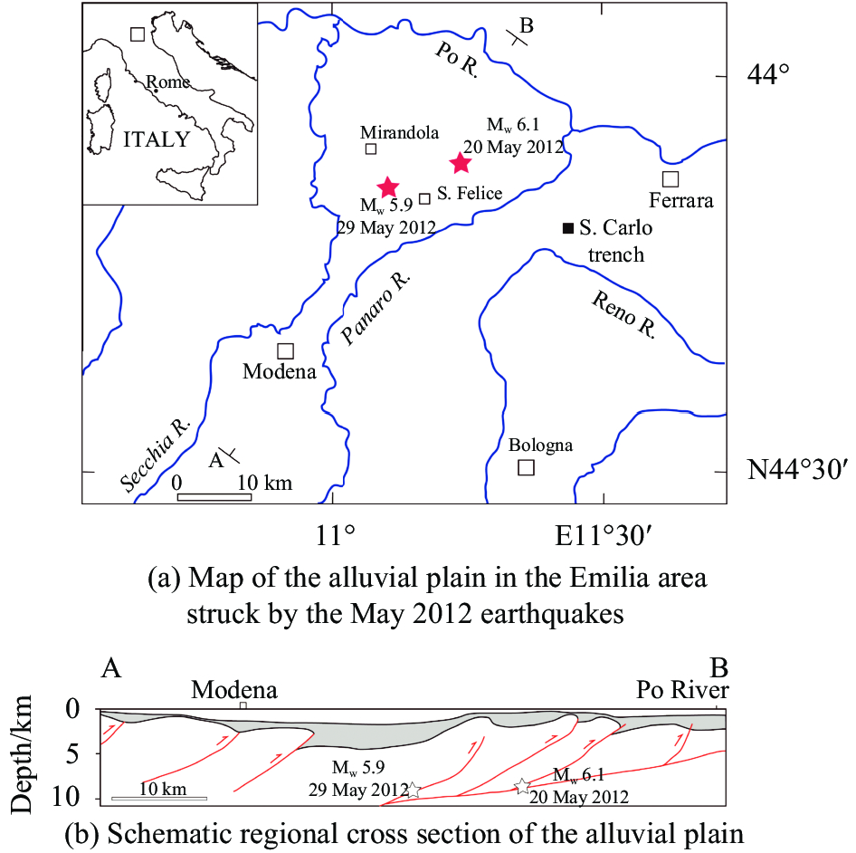 |
| Fig. 1 Research region |
The first shaking produced liquefaction phenomena, surface fracturing and sand ejection in an area of about 500 km2 in a radius of more than 20 km from the epicenter. These phenomena may pose a high risk of destruction and damage to structures and human activities, and for these reasons the geotechnical conditions for their occurrence need to be assessed in detail[2]. This is particularly important because, although mostly limited to sands, even gravelly sediments can be susceptible to liquefaction during high-energetic shaking, as demonstrated in 2008 during the Ms 8.0 Wenchuan earthquake, Sichuan province, China[3].
This paper reviews the results of this present research in the Emilia area aimed to provide a better understanding of earthquake-induced liquefaction mechanisms[4–5].
1 Socio-economic impact of the earthquakeThe seismic crisis caused 28 deaths, 300 injured and displaced about 45 000 people from their home. The earthquakes disrupted an area characterized by high economic productivity, which was performing about 2% of the national Gross Domestic Product (GDP). The economic activity was characterized by a number of medium-size companies which were important parts of the global production chain for the automotive and biomedical industry. After five years of reconstruction and recovery the GDP is today higher than that before the seismic crisis[6]. The total estimated damages amount to 13 billion Euros, which is about 0.8% of the 2012 GDP, including the emergency measures (€0.7 billion), damage to residential housing (€3.3 billion), and damage to companies (€5.2 billion). The town facing the greatest loss is Mirandola, with an estimated loss of approximately 245 million Euro. The estimated cost to residential buildings ranged from 900 million to a maximum of 2 000 million Euro[7] and the Emilia-Romagna Region has already granted about 2 000 million Euro for the reconstruction of residential buildings and commercial areas[6]. Great damage was suffered by the cultural heritage as many ancient buildings as old as the 13th century were completely or partially destroyed (Fig. 2 and Fig. 3).
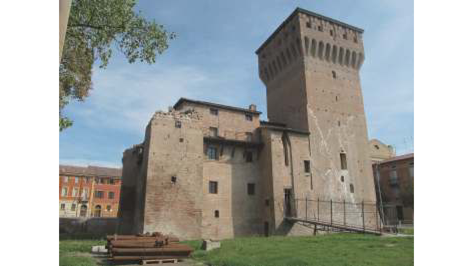 |
| Fig. 2 Finale Emilia castle damaged by the earthquake |
The Finale Emilia castle (Fig. 2 ) was built in 1402, the Finale Emilia castle was seriously damaged by the seismic crisis. This picture taken five months after the main earthquakes shows the emergency reinforcement used to prevent the collapse of the main tower (right), which was dissected and partially displaced by large fractures. Waiting for restoration works, the open fractures in the body of the main tower were injected with binding mortars and resins (white) and the top was completely encircled with steel ties. Unfortunately the top of the other three smaller angular towers collapsed (left).
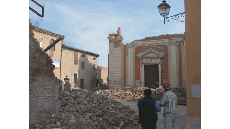 |
| Fig. 3 One of the 296 churches damaged by the earthquake as seen in October 2012, five months after the main earthquakes, Cavezzo, Modena |
2 Geological setting
The Emilia area is an alluvial plain area located above the buried sector of the Northern Apennine fold-and-thrust belt where the main rivers flow northeastward into the Po River (Fig. 1). The Northern Apennines formed during the Neogene convergence between the European and the Adria plates. The Apennine chain units are unconformably overlain by Miocene-Pliocene and Quaternary marine and continental terrigenous sediments. The Emilia floodplain is the syntectonic sedimentary wedge filling the foredeep of the Northern Apennine chain with an up to 4 km-thick Pliocene-Pleistocene sequence (Fig. 1). In this area, the Quaternary cover reaches a thickness of 1.5 km and was deposited following the contrasting subsidence regimes induced by the vertical motions of buried blind thrusts[8].The 2012 earthquakes were the results of the tectonic movements along one of these buried thrust systems: The Ferrara fold-fault system[9]. The river network continuously shifted laterally because of climate changes and local tectonic events, as revealed by the paleochannel traces visible on the alluvial plain surface. The older sedimentary patterns can be traced by the provenance composition signals of buried Holocene channel sands[10]. Most liquefaction phenomena[11] occurred along an old channel of the Reno River, which was active until the end of the 18th century when it was artificially diverted.
3 Materials and methodsWe performed the survey, sampling and analyses of the liquefaction phenomena in the immediate aftermath of the earthquake. Because vegetation growth, human activity and exposure to rain would have rapidly obliterated most of the surface effects of the earthquake, an aerial survey was immediately performed from an average altitude of 200 m using a specially-adapted aircraft. About 2 000 high-resolution digital photos were systematically taken to record even minimal superficial effects over an area of 500 km2. All the superficial geological phenomena have been classified and georeferenced. A systematic check on the ground was also carried out for each single occurrence.
After the field survey, the injected sands were sampled across the entire area. Particularly detailed was the sampling in a trench dug near San Carlo by the geological, seismic and soil survey of the Emilia Romagna Region, which allowed the observation of the sedimentary sequence of the Reno River down to a depth of about 7 m (Fig. 4). The sediments consist of sands deposited from the paleochannel of the Reno River and silty sands from the levee, cut by sand dykes produced by liquefaction phenomena. Other sand layers down to a depth of about 50 m were also sampled from cores drilled next to the paleochannel. Sands samples from the present-day Reno River channel were also analyzed for comparison. We performed grain-size analyses and petrographic composition of the sands.
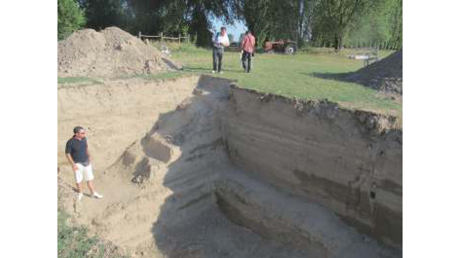 |
| Fig. 4 View of the trench dug across the fractures cutting the ancient riverbed of the Reno River, San Carlo, Ferrara |
4 Results and discussion
The aerial and field survey allowed to identify more than 700 superficial earthquake-induced geological phenomena. They consist of: sand volcanoes (Fig. 5), eruption of sand and water from fissures, building foundations and domestic wells, tension cracks (Fig. 6) and graben-like fissures, ‘dry craters’ (or sink-holes), lateral spreading effects on slopes and small collapses features along the banks of irrigation ditches. The survey demonstrated that most of the sand eruptions and tension fissures occurred along paleochannels and crevasse splay deposits. Seventy percent of the earthquake-induced features formed within urban areas and 30% in open cultivated areas. As the abandoned river channels form ridges elevated above the fluvial plain, they represented a preferred location for human settlement also for the availability of water that can be reached digging shallow-depth wells.
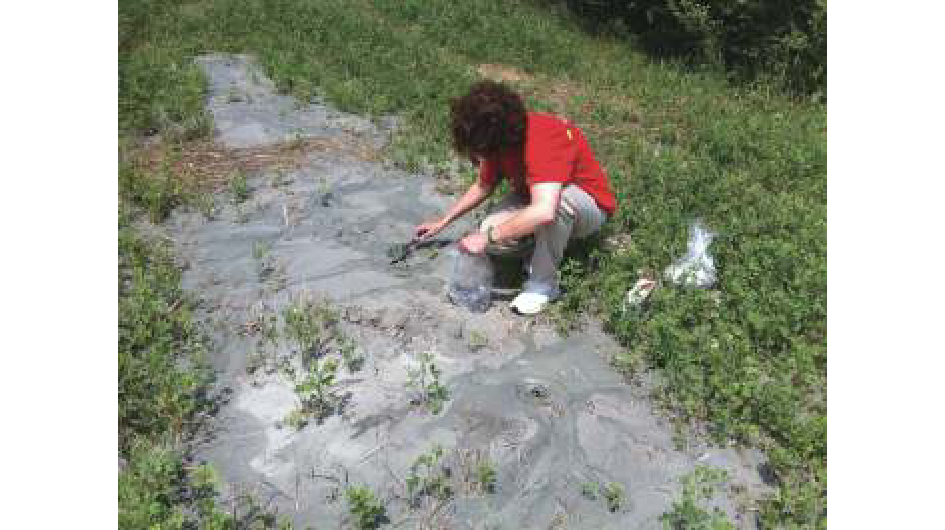 |
| Fig. 5 Sand volcanoes formed by emission of water and sand along fractures in a crop field, Cavezzo, Modena |
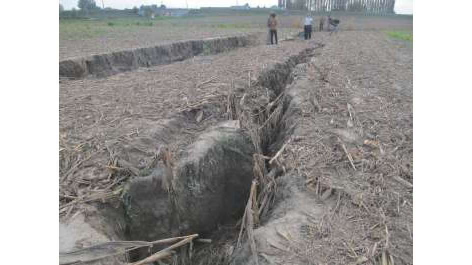 |
| Fig. 6 Largest fractures open during the earthquake as seen in October 2012, five months after the main earthquakes, Cavezzo, Modena |
The seismically-induced sand dikes in the trench consist of single and bifurcated vertical straigt, planar or curved extensional features. The sand injected into the fractures shows longitudinal or perpendicular banding with normal and inverse vertical grading from medium sand to mud (Fig. 7). Sedimentary dykes filled with sand as visible in the trench of Fig. 4 scale in centimeters.
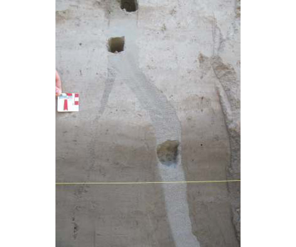 |
| Fig. 7 Holes are the sampling sites for the sand analyzed in this study, San Carlo, Ferrara |
The observed sedimentary features in the sand-filled fissures suggest a rhythmical injection back and forth along the fractures during compression and extension pulses, as observed during the Mw 9.0 Tohoku earthquake of Japan. Grain-size distribution, clay content and sand composition indicate that the sand source of the blowouts were layers at very shallow depth of 6.8 and 7.5 m, which consist of lithoarenitic to quartz- and feldspar-rich sands. The older Holocene and Pleistocene sand layers located below are richer in quartz and feldspar and poorer in sedimentary lithic fragments and thus are not compatible with the characteristics of the injected sands.
5 ConclusionThis present study showed the pivotal importance of a quick aerial survey able to pinpoint the sand blows in areas that may be badly visible from the ground and may be rapidly degraded and hidden by vegetation growth. The survey provided us with a complete record of even very small occurrences that were quickly checked directly in the field.
The petrographic composition of the sand and the study of all the cores drilled in the area provided the stratigraphic background that is the first step to build a 3D stratigraphic model of the underground. The model and the detailed information on the local stratigraphy are the fundamental tools to identify the sand layers, which may be susceptible to liquefaction. This present study demonstrated that the high-risk areas are located along river paleo-channels and crevasse-splays and that the sand layers source of the liquefaction phenomena are very close to the surface, within 6 to 8 m deep.
These results are of great interest in the structural evaluation for the construction of new buildings and the reinforcement of old ones. Following the evidence provided by the seismic crisis of 2012, the regional legislation has been updated to minimize the risk posed by liquefaction phenomena.
| [1] |
Pondrelli S,Salimbeni S,Perfetti P,et al. Quick regional centroid moment tensor solutions for the Emilia 2012 (Northern Italy) seismic sequence[J]. Annals of Geophysics, 2012, 55(4): 660-655. DOI:10.4401/ag-6146 |
| [2] |
Chang W,Ni S,Huang A,et al. Geotechnical reconnaissance and liquefaction analyses of a liquefaction site with silty fine sand in Southern Taiwan[J]. Engineering Geology, 2011, 123(3): 235-245. DOI:10.1016/j.enggeo.2011.09.003 |
| [3] |
Chen L,Hou L,Cao Z,et al.Liquefaction investigation of Wenchuan earthquake[C].The 14th World Conference on Earthquake Engineering,Beijing,China,2008:S31–049.
|
| [4] |
Bertolini G,Fioroni C. Aerial inventory of surficial geological effects induced by the recent Emilia earthquake (Italy):Preliminary report[J]. Annals of geophysics, 2012, 55(4): 780-784. DOI:10.4401/ag-6113 |
| [5] |
Fontana D,Lugli S,Dori M S,et al. Sedimentology and composition of sands injected during the seismic crisis of May 2012(Emilia,Italy):Clues for source layer identification and liquefaction regime[J]. Sedimentary Geology, 2015, 325: 158-167. DOI:10.1016/j.sedgeo.2015.06.004 |
| [6] |
2012-2017,L’Emilia dopo il sisma,report su cinque anni di ricostruzione[R].Regione Emilia-Romagna,2007.
|
| [7] |
Meroni F,Squarcina T,Pessina V,et al. A damage scenario for the 2012 northern Italy earthquakes and estimation of the economic losses to residential buildings[J]. International Journal of Disaster Risk Science, 2017, 8(3): 326-341. DOI:10.1007/s13753-017-0142-9 |
| [8] |
Amorosi A,Pavesi M,Lucchi M R,et al. Climatic signature of cyclic fluvial architecture from the Quaternary of the central Po Plain,Italy[J]. Sedimentary Geology, 2008, 209(1): 58-68. DOI:10.1016/j.sedgeo.2008.06.010 |
| [9] |
Pieri M,Groppi G. Subsurface geological structure of the Po Plain,Italy[J]. C. N. R.,Progetto Finalizzato Geodinamica, 1981, 414: 1-13. |
| [10] |
Lugli S,Dori S M,Fontana D. Alluvial sand composition as a tool to unravel the late Quaternary sedimentation of the Modena Plain,Northern Italy[J]. Special Paper of the Geological Society of America, 2007, 420: 57-72. DOI:10.1130/2006.2420(05) |
| [11] |
Papathanassiou G,Mantovani A,Tarabusi G,et al. Assessment of liquefaction potential for two liquefaction prone area considering the May 20,2012 Emilia (Italy) earthquake[J]. Engeneering Geology, 2015, 189: 1-16. DOI:10.1016/j.enggeo.2015.02.002 |
 2018, Vol. 50

